The notification hit phones before dawn, glowing on bedside tables across the northern U.S. and Europe: “Major polar vortex disruption likely in early January.”
Outside, the air didn’t feel particularly dramatic. A little sharper on the cheeks, a thin layer of frost on the windshield, traffic moving as usual.
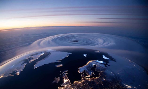
Yet high above all of that calm, around 30 kilometers up, the atmosphere was twisting into a shape that has scientists sitting up straighter in their chairs.
What’s forming over the Arctic right now is being called one of the strongest early-season polar vortex shifts on record for January.
And the strangest part is, we’ve barely stepped into the heart of winter.
A polar vortex that’s misbehaving far too early
On weather maps that only experts usually stare at, the polar vortex is starting to look broken.
Instead of a tight circle of bitter cold locked neatly over the North Pole, models show it stretching, wobbling, and potentially splitting into separate lobes.
For early January, that’s a big deal.
These major disruptions usually wait until late winter, when the atmosphere has had months to build tension.
This year, the disruption is barging in almost a month ahead of schedule, and some of the numbers coming out of forecast centers are being described as “near unprecedented” for this time of year.
If that sounds abstract, picture this.
Back in January 2021, a polar vortex disruption sent Arctic air pouring into the central U.S., helping set the stage for Texas’ deep freeze a few weeks later. Pipes burst, grids failed, people slept in parked cars to stay warm.
Scientists are now watching the current event with that memory in the back of their minds.
The stratosphere over the Arctic is warming fast, tens of degrees Celsius in just a few days, flipping the usual pattern. That rapid warming weakens the polar vortex, like loosening the lid on a freezer.
Once that “lid” shifts, the cold air inside can spill south, though exactly where and when is still a high-stakes guessing game.
So what’s driving this early-season punch?
Specialists point to a chain of events: strong wave patterns in the North Pacific, unusual jet stream kinks over Eurasia, and persistent blocking highs that keep shoving energy upward into the stratosphere.
When that energy slams into the polar vortex, it slows, deforms, sometimes tears apart.
For early January, the scale of this attack on the vortex stands out in the reanalysis data. Several research groups say the intensity of the projected warming ranks among the strongest January events since reliable satellite records began in the late 1970s.
*The atmosphere isn’t just drifting this winter, it’s taking sharp turns.*
What this could mean down here on the ground
If you’re wondering what to actually do about all this, start simple: watch the 10–20 day forecast window like you’d watch a bank account when rent is due.
Polar vortex shifts don’t usually slam you the next morning. They work on a delay.
➡️ Emergency declared in Greenland as researchers spot orcas breaching near melting ice shelves
➡️ Plant this fruit now for abundant spring harvests
➡️ Microsoft launches its first AI superfactory to train giant models in weeks
➡️ “I feel uneasy with stillness”: psychology explains self-confrontation
➡️ No more hair dye : the new trend that covers grey hair and makes you look younger
Typically, the stratospheric disruption unfolds first, then over one to three weeks, the lower atmosphere “feels” it.
That delayed reaction is when patterns can flip: mild spells crash into Arctic outbreaks, storms find new tracks, some regions get locked into repeated cold shots while others stay oddly warm.
For January travel plans, energy bills, and even school schedules, that lag time is where small choices now can spare big headaches later.
We’ve all been there, that moment when you underestimate the cold snap and end up chiseling ice off your windshield with an old loyalty card.
During a disrupted polar vortex year, those moments can stack up faster than usual.
In Europe, past events have brought prolonged freezing spells from Scandinavia down into Germany and the UK. In North America, the Midwest and Northeast are often in the line of fire, though not every event plays out the same.
Some years, the main cold lobe dives into Siberia instead, leaving the U.S. relatively spared but hammering parts of Asia.
The point is: once the vortex shifts, weather patterns stop behaving like the smooth, gentle winter most long-range outlooks hinted at back in November.
Behind the headlines is a quieter, more technical anxiety.
Long-term climate trends show the Arctic warming far faster than mid-latitudes. That shrinking temperature contrast can alter jet streams, storm paths, and, yes, how the polar vortex behaves.
Researchers are still debating the exact links, and honest scientists will tell you the story isn’t fully written.
Yet a growing body of studies suggests that as sea ice retreats and the Arctic “opens up”, disruptions in the stratosphere may become more frequent or more intense.
Let’s be honest: nobody really has a perfect, neat model for a planet warming this fast.
How to read the signals like a weather pro (without living on Twitter)
You don’t need to understand every chart flying around on meteorologists’ feeds, but a couple of signals are worth keeping on your radar.
First: keep an eye on phrases like “Sudden Stratospheric Warming” or “major SSW event confirmed.” That’s often the official label for the kind of strong polar vortex disruption unfolding now.
Second: look for mentions of “downward propagation” into the troposphere. That’s the science-speak for when the chaos upstairs starts changing the weather where planes actually fly and where we live.
When forecasters begin talking about those signals lining up, you’re entering the window where big pattern shifts can actually hit your city, not just the Arctic.
The biggest mistake people fall into is treating every polar vortex headline like a guaranteed snow apocalypse.
Most of these events don’t deliver blockbuster blizzards to everyone, and some bring more dry cold than dramatic drifts.
Another common trap is checking the 10-day forecast once, panicking, then tuning out completely. Patterns tied to vortex disruptions can evolve day by day.
A storm track that looks harmless at the start of the week can suddenly tilt, feeding off that new cold source.
If you have kids, elderly relatives, or just a drafty old house, staying loosely plugged into updates can be the difference between scrambling and calmly plugging in a space heater.
“From a stratospheric perspective, this is a standout January event,” says one senior atmospheric scientist at a European forecast center. “We’re in territory we don’t see often so early in the year, and that raises the stakes for late-month and February patterns across the mid-latitudes.”
- Follow trusted sources: National meteorological agencies, reputable university climate labs, and a handful of veteran forecasters are your best bet when models start swinging wildly.
- Think in scenarios, not certainties: When experts mention “cold risks increasing” or “heightened chance of blocking,” that’s your cue to mentally budget for a rougher stretch of winter, not to stockpile for an ice age.
- Use the 3–7 day window for real decisions: That’s where the polar vortex story filters into concrete advice like school closures, travel warnings, or grid strain alerts that actually change your plans.
A winter story still being written above our heads
Right now, above the night lights of Chicago, Berlin, Montreal, Warsaw, and a hundred smaller towns in between, the sky looks peaceful.
No one walking the dog at 10 p.m. can feel a 40-degree spike in the stratosphere or see the polar vortex twisting on a weather model.
Yet those invisible shifts are already nudging the dice for the rest of this winter.
Energy traders, school districts, and airport planners are quietly recalculating. Parents are wondering if the sleds in the garage will finally earn their keep, or if this will be another weird, brown winter with cold that bites but snow that never really commits.
The early, intense nature of this January disruption makes it more than just another seasonal headline.
It’s a reminder that the old rules of winter are loosening, that “average” seasons are becoming the exception, not the norm.
For some, that means longer thaws and fewer snow days. For others, it means deeper, sharper cold snapping in on shorter notice than they grew up with.
The polar vortex has become a kind of character in the climate story we’re all living through, popping up every few years with a new twist, a new lesson, and fresh questions.
You don’t have to become an amateur meteorologist to feel the weight of those questions.
You just have to notice how often, lately, the weather feels slightly off-script.
An early-season vortex shift this powerful is another nudge: the atmosphere is changing in ways our parents didn’t have to think about.
Where that leads over the next few decades is still up for debate, messy, and honestly a bit unsettling.
But paying attention now, to events like the one building quietly over the Arctic this January, is part of learning to live on a planet that’s rewriting its own winter rules in real time.
| Key point | Detail | Value for the reader |
|---|---|---|
| Early, intense disruption | One of the strongest polar vortex shifts ever modeled for January | Helps you understand why this winter may not follow “normal” patterns |
| Lag between cause and effect | Impacts often show up 1–3 weeks after the stratospheric event | Gives you a realistic window to prepare for cold snaps and travel issues |
| Practical monitoring | Watch for SSW alerts, downward propagation talk, and 3–7 day forecast changes | Lets you act on credible signals instead of reacting to every viral headline |
FAQ:
- Question 1What exactly is the polar vortex, in simple terms?
- Answer 1It’s a large, persistent whirlpool of very cold air high above the Arctic, spinning counterclockwise in winter. When it’s strong and stable, that cold stays mostly locked up north; when it breaks down or shifts, some of that air can spill south into North America, Europe, or Asia.
- Question 2Does a strong polar vortex disruption always mean extreme cold where I live?
- Answer 2No. A disruption raises the odds of big pattern changes, but where the cold actually lands depends on how the jet stream bends. Some regions get severe outbreaks, others stay mild, and a few sit in between with wild swings.
- Question 3Why are experts calling this January event “near unprecedented”?
- Answer 3Because the intensity of the warming in the stratosphere and the strength of the hit to the polar vortex are unusually strong for early January. Historical data show that this kind of disruption is more typical later in winter, which makes the timing and magnitude stand out.
- Question 4Is climate change causing more polar vortex events?
- Answer 4Science hasn’t settled that fully yet. Some studies suggest a warming Arctic and loss of sea ice can make the atmosphere more prone to these disruptions, while other work finds weaker links. Most researchers agree the background climate is changing, and that likely influences how the vortex behaves, just not in a perfectly predictable way.
- Question 5What should I realistically do over the next few weeks?
- Answer 5Stay casually tuned to updates from a trusted national weather service, check the 3–7 day forecast a bit more often than usual, and be ready for a sharper turn in winter conditions. That could mean adjusting travel, protecting pipes, or simply budgeting for a bigger heating bill if your region ends up under one of the cold lobes.