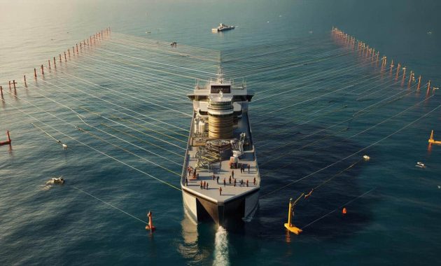
It looks blunt from above, almost like a slice torn from a triangle. That shape isn’t a gimmick. It’s the signature of the Ramform Titan, a seismic-survey vessel built in Japan for Norway’s PGS, and it exists for one reason: to listen to rock. The ship’s job is to map what lies beneath the seabed with unnerving precision, then hand that data to energy firms and researchers hunting structure, traps and faults.
The floating trapezoid that listens to rock
Launched in 2013 by Mitsubishi Heavy Industries in Nagasaki, the Ramform Titan redefined how wide a ship’s stern could be without losing control. It measures 104.2 meters long but an extraordinary 70 meters across at the stern. That rear deck width is the trick. It gives the crew room to launch and manage an armada of towed sensors while keeping them stable in rough water.
Widest stern at sea, 24 seismic streamers up to 12 km each, and a mission measured in months: the Titan turns ocean into x‑ray.
Why the shape works
Seismic data quality rises with coverage and stability. The ship tows long “streamers” fitted with hydrophones—microphones for water—that listen for sound reflected off subsurface layers. A wide stern keeps those streamers spread evenly, like the ribs of a fan, reducing tangles and cross-talk. The Titan can tow up to 24 streamers at once, each around 12 kilometers, forming a spread wider than a city.
- Triangular stern maximizes deck area for reels and winches.
- Greater beam boosts transverse stability at low survey speeds.
- Clean separation between streamers improves signal-to-noise ratio.
- Towed gear can be reconfigured quickly to target complex geology.
How a seismic survey actually works
The process sounds simple on paper. The vessel fires tightly controlled pulses of compressed air—“air guns”—into the water. Those pulses travel through water, then rock. At each boundary in the subsurface, part of the energy reflects upward. The streamers pick up the echoes, and the onboard systems time them to the microsecond. Positioning buoys and GPS fix every sensor’s location. Software stitches the echoes into a 3D image of the rock layers.
Dozens of parallel lines, thousands of sensors, and billions of data points feed a live 3D model the crew watches build in real time.
From 3D to 4D
Run the same survey later and compare the results, and you get time-lapse seismic—often called 4D. Subtle changes in the rock’s response can reveal how fluids move in a reservoir, helping operators place wells more accurately or monitor a depleted field used for carbon storage.
An industrial deck with a data center beneath
The rear deck stacks 24 heavy reels across multiple levels. Launch and recovery feel like choreography: one streamer pays out while another comes home for repair, paravanes hold the wings steady, and tension stays within a tight envelope. The ship tows six air-gun arrays, each fed by compressors below deck.
Under the steel, a control room runs nonstop. Navigation, acoustic positioning, temperature profiles, and sound-speed measurements pour into servers. First-pass processing happens on board to check quality, spot gaps, and steer the next line. Final crunching comes later on land, but crews want quick answers offshore to avoid rework.
➡️ Abdominal fat after 60 : the easiest, most effective exercise you’re not doing
Power and control
The Titan uses three controllable-pitch propellers driven by electric motors rated at roughly 6,000 kW apiece. Six diesel engines supply the juice. The ship can make about 15.5 knots in transit and around 5 knots when towing full gear. At survey speed, handling, not haste, wins the day.
| Overall length | 104.2 m |
| Beam at stern | 70.0 m |
| Draft (summer) | 6.42 m |
| Transit / tow speed | ~15.5 kn / ~5 kn |
| Propulsion | Electric drive, 3 CPP propellers (3 × ~6,000 kW) |
| Main gensets | 6 × ~3,840 kW |
| Streamer capacity | 24 reels, ~12 km per streamer |
| Crew | About 80 |
| Class & codes | DNV +1A1, ICE‑C, HELDK, RP, Clean Design; SPS Code 2008 |
| Builder / client | MHI Nagasaki, Japan / PGS, Norway |
Life on a ship that never really stops
Seismic work runs in shifts around the clock. Missions can last months. The Titan was designed less like a trawler, more like a compact campus. Single cabins keep noise down. There’s a gym, sauna, an outdoor pool, and a small indoor court that doubles as a morale valve during weather holds. A helideck handles crew change and spares, so the lines can keep running while the people turn over.
Safety, class and what that means at sea
Specialized ships carrying technical staff fall under the IMO’s SPS Code. The Titan also carries DNV’s Clean Design notation, which pushes tighter control of emissions and discharges. Ice‑C class allows limited ice operations, useful in high latitudes during short fair-weather windows. Those badges sound bureaucratic, but they shape real details: redundant systems, fire protection around compressors, controlled chemical handling, and strict watch procedures when towing a small forest of gear.
What the data is used for now
Yes, oil and gas remain the core market. Detailed seismic lowers drilling risk, which saves money and reduces unnecessary wells. But the same imaging helps with new priorities. Offshore wind developers need clean maps to route cables and anchor foundations. Governments survey for hazards on subduction margins. And carbon storage projects use seismic to characterize reservoir traps and then monitor the injected CO₂ plume over time.
Better pictures of the subsurface cut risk: fewer dry holes, safer foundations, clearer monitoring of carbon storage.
Noise, whales and mitigation
Air guns generate intense sound. That raises concerns for marine mammals and fish. Operators now follow layered safeguards: soft starts that ramp power, exclusion zones monitored by trained observers, passive acoustic monitoring for vocalizing animals, and seasonal restrictions in sensitive areas. Research continues into alternative sources and smarter signal processing to reduce source levels while keeping image quality.
Why Japan built it, and why it still matters
For Mitsubishi Heavy Industries, the first Ramform Titan class was a statement of capability in high‑precision, high‑value shipbuilding. The design mixed naval architecture with deep data engineering. Success led to sister ships and a steady niche: complex vessels that carry more compute than cargo.
The market keeps changing. Energy companies chase lower-cost barrels and better subsurface models. States want clearer hazard maps. And the energy transition adds new use cases—wind siting, cable burial, and CO₂ storage assurance. Ships like the Titan sit in the middle of that puzzle, turning sound into decisions.
A typical survey day, in practice
At dawn, line steering shifts over with a handoff in the control room. The ship holds a dead-straight course. Compressors hum. The array fires on a precise shot interval tied to speed over ground. Streamer birds—little winged devices—adjust depth and feathering. Quality-control screens flag any channel dropouts. If a fishing buoy appears on radar, a workboat is launched to guide it around the spread rather than risk a snag. The only drama anyone wants is on the seismic section, when a bright amplitude hints at something new.
Extra context to read the numbers on the page
What “4D seismic” really adds
Think of the first 3D survey as a baseline MRI. A repeat run months or years later reveals fluid movement and pressure changes underground. Engineers then tweak injection rates, reposition producers, or, for storage, confirm that the injected CO₂ stays trapped under the caprock. Time-lapse can turn a rough guess into a measurable trend line.
Trade-offs crews juggle on every line
Longer streamers see deeper and separate noise better, but they demand wider turns and more space to avoid collisions. More streamers boost coverage, yet increase drag and fuel burn. Tighter line spacing fills gaps for sharper images, while raising costs. The Titan’s big stern and power budget were designed to push those trade-offs toward better pictures without losing the practical battle with weather and time.