After weeks under a sleepy ridge of high pressure, guidance flips to a brisk west-to-north regime. Bands of rain thicken. Snow lines edge downward. Nights lean sharper. The change arrives fast and then keeps pulsing through the second half of November.
Pattern shift over central Europe
Forecast charts now retire the stagnant fog-and-drizzle setup. Lows from the North Atlantic begin to queue up. They sweep fronts across Germany, drag in colder air from the north, and shake up the temperature profile. The mix turns messy and wintry, especially when wet air lifts over cooling ground at night.
That transition matters. When the cold push holds long enough, the freezing level collapses. Hills and uplands turn white first. Lowlands feel a raw chill and see wintry showers that flirt with sticking. The potential hinges on how firmly a trough settles over central Europe and how long the northerly feed persists.
Key takeaway: If the northerly supply stays open through successive fronts, snow can reach the lowlands and briefly settle.
What the models show
European ensemble runs point to a turbulent, early-winter flavor. Repeated Atlantic lows bring showers, squally winds, and a tap of Arctic-sourced air. The snow line falls into the medium hills, with the Harz, the Ore Mountains and the Alpine foothills best placed for the first meaningful accumulations.
For the flatlands, duration decides. A lasting northerly push sets the stage for wet snow and slush, particularly in Lower Saxony, Thuringia, and southern Brandenburg. If temperatures dip a shade lower overnight, some spots could wake to a coating on rooftops, cars, and lawns.
First widespread sub-zero nights look likely, with colder hollows dipping near -10 C (14 F) if skies clear and winds drop.
Why 2010 is a tempting but shaky comparison
Memories drift back to December 2010, when a blocking pattern locked Europe in snow and ice for weeks. That event leaned on a persistently negative phase of the North Atlantic Oscillation, which kept mild maritime air at bay. Today’s charts flirt with similar ingredients but lack a rock-solid block.
Expect a stop-start version instead: regional snow, alternating cold and milder spells, and sharp night frosts between fronts. Forecasters peg the odds of a true 2010-style repeat somewhere around 10–20 percent. That is not the base case. Still, a few early snowfalls could prime the ground, cool soils, and make subsequent cold snaps more effective.
Early snow cover acts like a cold battery. It cools the surface, reduces daytime melt, and helps the next cold surge bite harder.
➡️ This “easy” plant is taking over French gardens – and it’s not always good news
➡️ Ukraine wants 20-year US security guarantee to sign peace deal
➡️ India signs €7.7 billion deal with Germany for high-tech submarines
➡️ Microwaving a lemon : A simple kitchen trick you’ll keep using
➡️ China unearths a 2,200-year-old imperial road that challenges our modern highways
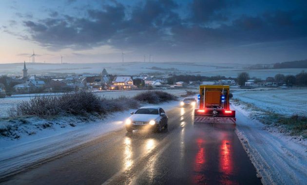
What to expect on the ground this week
The Deutscher Wetterdienst flags a quick slide to wintry hazards. Commuters face slick mornings, especially after nocturnal clear spells. Upland routes could see compacted snow and drifting under squalls. Daytime breaks will occur, but wet surfaces can flash-freeze after dusk.
Regional snapshot
- Alpine foothills and Allgäu: Frequent snow showers, plowable totals on higher roads, gusty passes.
- Harz and Ore Mountains: High odds for snow, icy stretches in valleys, drifting on exposed ridges.
- Lower Saxony, Thuringia, southern Brandenburg: Mixed rain-and-snow, short-lived coverings during cold pulses.
- Rhineland and lower Rhine: Mostly cold rain, brief sleet in heavier bursts overnight.
- Coastal north: Windy, squally showers, graupel and wet snow in heavier cells.
| Elevation band | Main precipitation type | Likely outcome |
|---|---|---|
| 0–200 m | Rain, sleet, brief wet snow at night | Slushy coatings in colder pockets, quick melt by day |
| 200–600 m | Snow showers, rain/snow mixes | Settling on grass and secondary roads, icy mornings |
| 600 m+ | Frequent snow | Plowable accumulations, drifting in gusts |
Signals behind the scenes
Meteorologists watch two big players in the background. The stratospheric polar vortex shows early-season wobble. A weaker, more distorted vortex can leak colder air masses toward Europe. The North Atlantic Oscillation is flirting with negative phases at times, which nudges storm tracks south and opens the door to cold intrusions from Scandinavia.
These signals are not guarantees. They shape probabilities. If a transient block forms near Greenland, it amplifies the northerly flow and prolongs cold spells across Germany. If Atlantic lows strengthen and push through, milder, rainier interludes return and trim snow chances outside higher ground.
A brief Greenland high would prop open the northern gate, sending repeated cold shots into Germany and lowering snow lines.
Travel and daily life: practical notes
Germany’s “situational” winter tire rule applies when roads turn wintry, not just by date. Drivers should switch to winter or all-season tires marked with the snowflake symbol. Pack de-icer, a scraper, and a small shovel if you live above 300 meters. Leave extra braking distance as temperatures fall after sunset.
Rail travelers may face speed restrictions on exposed routes during squally spells. Regional airports sometimes need de-icing queues during frosty mornings. Power demand rises during the first cold snap of the season, which can add strain to morning peaks.
Odds for a white Christmas
People will ask. The honest answer leans cautiously positive for uplands and alpine-adjacent regions. Lowland odds improve if late November lays down early snow cover and if December repeats the northerly feed every few days. A single mild surge can wipe the slate clean, so persistence matters more than one big event.
How to track the next steps
Watch three checkpoints over the coming week. First, whether night skies clear after fronts, which boosts ground cooling. Second, whether a Greenland ridge flickers on ensemble means, a key enabler of sustained cold. Third, how low the snow line sits during the strongest showers. Those details shape how quickly cities move from slush to something that sticks.
Extra context for weather-curious readers
North Atlantic Oscillation: When this index trends negative, pressure rises near Greenland while pressure drops farther south. Storms dive toward France and Germany. Colder, drier air leaks in from the north and east. Snow risks rise where frontal bands overlap the cold pool.
Stratospheric polar vortex: A strong, symmetric vortex usually keeps the deepest cold locked near the Arctic. A weakened, lopsided vortex can send lobes of cold south. Early-season tremors do not equal a mid-winter split, yet they tilt the odds toward more frequent cold intrusions.
Simple planning tip: Run a quick home “freeze test.” On the first clear night after a front, place a cup of water outside at 9 p.m. Check it at 6 a.m. If you see ice, your local microclimate supports overnight freezing, and untreated pavements nearby likely glazed too.