The first hint that something was off came in the most ordinary way: a phone weather alert during a boring Tuesday commute. Outside, people were walking in light jackets, kids kicking a football in a half-dry park. Spring was obviously on the way. Then the notification flashed: “Major stratospheric warming event detected. Possible polar vortex disruption.” Most people just swiped it away, the same way we ignore those “once in a decade” headlines that now seem to pop up every six months. But behind that tiny red icon, the atmosphere was quietly twisting into one of the strangest March patterns meteorologists have ever seen. A winter beast, waking up late. One that doesn’t usually show up this close to April.
A polar vortex upset… when we’re already dreaming of spring
Across much of the Northern Hemisphere, the seasonal script is supposed to be simple in March: longer days, softer light, that tentative moment when you think, “Maybe I don’t need the heavy coat today.” This year, the script is being ripped up by a polar vortex disruption so strong that seasoned forecasters are double-checking their charts. The stratosphere over the Arctic is heating dramatically, almost flipping the usual pattern on its head. High above our heads, winds that usually roar in a tight, icy circle are slowing, twisting, even reversing.
Down here at ground level, that sounds abstract. Up there, it’s the kind of shift that can yank winter back by the collar, right when we thought we’d made it. And this time, the timing is almost unheard of.
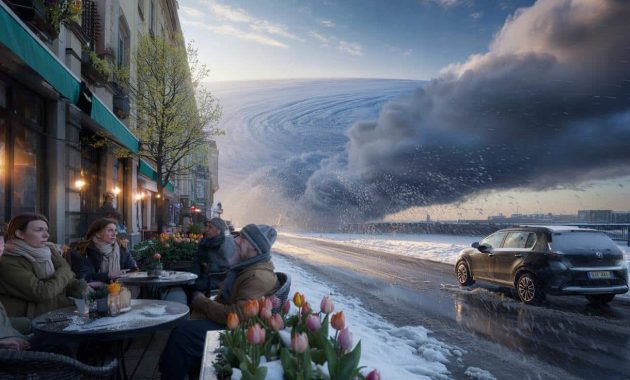
If this still feels a bit theoretical, picture this scene from northern Europe in early March a few years back, during the “Beast from the East.” Cafés had rolled out their first terrace tables of the year. People were sitting outside in scarves but smiling, faces tilted toward a watery sun. Then the disrupted polar vortex snapped, and Arctic air spilled south. Within days, the same sidewalks were buried under snowdrifts taller than toddlers. Trains froze in place. Fresh tulip buds were encased in ice.
That event, in late February and early March 2018, came after a sudden stratospheric warming that looks eerily similar, on the charts, to what’s forming now — except the current disruption is even more intense and later in the season. Some meteorologists are quietly calling it one of the strongest March disturbances they’ve ever tracked. Not just a wobble, but a full-on atmospheric plot twist.
So what does “polar vortex disruption” really mean, beyond a scary headline? Under normal conditions, the polar vortex is a tight ring of strong winds circling the Arctic, like a giant atmospheric fence. That fence keeps the coldest air bottled up near the pole. When the stratosphere above it suddenly warms by 30, 40, sometimes 50°C over just a few days, that fence starts to buckle. The vortex stretches, tilts, or splits like a cracked plate.
Cold air, once neatly contained, can then spill south in long tendrils. Not everywhere, not all at once, and not for the same length of time. But for the regions that get hit, the result can be shocking: snowstorms in places already stocked with garden soil and barbecue charcoal. That’s why scientists are sounding subtle alarms. Not to dramatize, but because the timing and magnitude of this March disruption stand out against decades of records.
What you can actually do when the sky can’t decide on a season
When forecasts start hinting at a late-season cold blast linked to a polar vortex shake-up, the instinct is either to panic-scroll or completely tune out. There is a saner middle path. The most practical move is to watch regional outlooks, not just generic headlines. Look at 10–15 day ensemble forecasts, which show the spread of possible temperatures. If you’re seeing repeated hints of a sharp drop, treat it like you would a storm warning: quietly, calmly adjust your plans.
For households, that might mean delaying the first big spring planting by a week or two. For city dwellers, it could be as simple as leaving winter coats and sturdy boots within reach instead of vacuum-sealing them away. For schools or workplaces, keeping a flexible eye on outdoor events in the second half of March suddenly matters. A polar vortex disruption doesn’t mean guaranteed chaos where you live — but it does mean the atmosphere is less “stable and predictable” than a typical March.
One common mistake is treating the first warm spell as a green light for summer behavior. We’ve all been there, that moment when you see 18°C on the app and decide winter is officially over. Then a week later, the wind swings north and you’re back to scraping ice off the windshield with a loyalty card because the proper scraper is buried in the garage. Gardeners know this pain especially well. Buds that break early are incredibly vulnerable to a late freeze, and this is exactly the kind of pattern that can deliver that kind of sting.
➡️ The world’s rarest parrot begins a historic breeding season
➡️ Three zodiac signs will end the year with an almost empty wallet
➡️ Nipah virus outbreak has Asia on high alert amid deaths in India : ScienceAlert
➡️ Writing your grocery list by hand: what psychology really reveals
➡️ 10 phrases to make people respect you
Let’s be honest: nobody really tracks stratospheric temperatures every single day. You don’t need to. But in years like this, when meteorologists start mentioning extreme polar vortex disruptions in March, it’s worth treating spring as provisional. Think of it as “beta spring”: enjoyable, but not yet the final release. For farmers, energy planners, and city services, that mindset shift can mean the difference between a small inconvenience and a real disruption.
“From a climate statistics point of view, what we’re seeing in March is highly unusual,” explains Dr. Laura Matthis, a stratosphere specialist at a European weather center. “The projected warming at 10 hPa over the pole is on par with major winter events, but we almost never see this magnitude so late in the season. It doesn’t guarantee severe weather on the ground, but it significantly raises the odds of late cold outbreaks.”
- Check localized forecasts for your city or region over the next 2–3 weeks, rather than relying on a single national map.
- Keep winter gear accessible — coats, gloves, windshield scrapers — until the threat window from this disruption has clearly passed.
- Delay sensitive planting by a short margin if your local outlook hints at a late freeze risk.
- Plan outdoor events with backup indoor options instead of assuming mild, stable spring weather.
- Follow a trusted meteorologist on social media who explains polar vortex updates in plain language.
A strange March that hints at a bigger story in the air
What’s unfolding above the Arctic this March is more than just a curiosity for weather geeks. It feels like another chapter in a new kind of seasonal uncertainty. Winters that start late, then come back for a final swing when cherry blossoms are already peeking out. Summers that flip from soggy to scorching in a week. The atmosphere is still obeying physics, but the patterns we grew up trusting feel less reliable. *That quiet sense of “I don’t really know what season it is anymore” has become oddly familiar.*
Scientists are still debating how much of this new volatility is directly tied to human-driven climate change and how much is natural variability. There’s genuine disagreement, and you’ll find solid papers arguing both sides. What’s not in dispute is that we are living through a stretch where “unusual” has become the baseline. A massive polar vortex disruption in March, nearing record strength, fits uncomfortably well into that story. It nudges us to pay attention, not just to this event, but to the patterns stacking up around it.
Maybe that attention starts small: checking forecasts with a bit more curiosity, asking where that cold surge actually comes from, noticing how often “once in a decade” turns into “again, already.” Maybe it’s talking with your kids when they ask why it’s snowing on the first day of spring vacation. Or sharing that slightly surreal feeling with a neighbor as you lug the snow shovel back out after mowing the lawn in the same month. The sky is sending mixed messages this year. Listening to them, and talking about them, is where our response begins.
| Key point | Detail | Value for the reader |
|---|---|---|
| Unusually strong March polar vortex disruption | Stratospheric warming and wind reversal over the Arctic reaching rare late-season levels | Helps you understand why forecasts are hinting at unexpected late cold spells |
| Potential for late cold outbreaks | Weakened vortex can let Arctic air spill into mid-latitudes over the next few weeks | Guides your decisions on clothing, travel, planting, and outdoor plans |
| Adapting to a new kind of seasonal uncertainty | Using flexible planning, local forecasts, and practical habits instead of fixed “rules” about seasons | Reduces stress and surprises as weather patterns grow more volatile |
FAQ:
- Is a polar vortex disruption the same as a “polar vortex storm”?
No. The polar vortex is a large-scale circulation of cold air high in the atmosphere, not a single storm. A disruption means this circulation weakens or splits, which can then set the stage for colder outbreaks and storms at the surface, but they’re not the same thing.- Does this mean my region will definitely see heavy snow in March?
Not necessarily. A disrupted vortex changes the odds, not the guarantee. Some regions may get severe cold and snow, others only a brief chill, and some might barely notice. Local forecasts remain your best guide.- Is this polar vortex disruption caused by climate change?
Scientists are still debating the exact link. Some studies suggest a warming Arctic can lead to more frequent or intense disruptions, while others find the connection weaker. What’s clear is that extremes are stacking up more often in a warming climate.- How long can the impacts from this March disruption last?
Once the stratosphere is strongly disturbed, surface impacts can play out over two to six weeks. That doesn’t mean constant cold, but periods of unusual chill or storminess can pop up during that window.- What’s the simplest practical step for me right now?
Keep an eye on 7–15 day forecasts and don’t fully “pack away” winter yet. A small dose of flexibility — in clothing, travel, and planting — is the easiest way to stay ahead of any surprise cold snaps linked to this event.