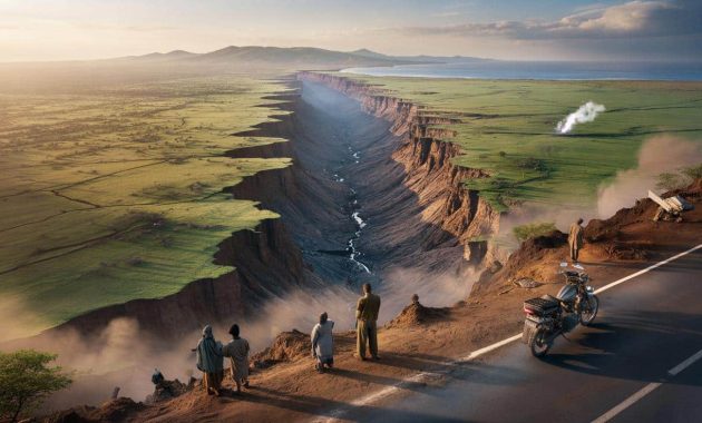
The first time I saw the video, I honestly thought it was CGI. A brown scar running through the green of East Africa, stretching across the land like someone had drawn a line with a giant knife. Dust hangs in the air. People stand at the edge of an enormous crack in the ground, staring down in silence. A motorbike is parked awkwardly nearby, like it got caught in a scene it didn’t sign up for.
Then you realize: this isn’t a movie set. This is the Earth, opening up.
And scientists are calmly saying that one day, that open wound could turn into a brand‑new ocean.
Africa is literally tearing apart — and we can see it from space
On a plateau in southern Kenya, farmers woke up in 2018 to find part of their world missing. Overnight, a fissure several kilometers long had opened in the ground, slicing through fields, grazing land, even a road. Asphalt simply dropped away. The images went viral: a ribbon of emptiness wide enough to swallow a bus, framed by puzzled cows and people filming on their phones.
Geologists rushed to the scene and said something that sounded almost unbelievable. This crack wasn’t just local damage from heavy rain. It was a visible sign of a continent slowly tearing itself in two.
Underneath East Africa, the planet has been stretching for millions of years. The African continent is being pulled apart along what scientists call the East African Rift System. From Ethiopia in the north to Mozambique in the south, a chain of faults, volcanoes, and valleys traces the line where two future landmasses are gradually drifting away from each other. Satellites track this movement with eerie precision.
They show the Somali plate inching away from the Nubian plate at roughly the speed your fingernails grow: a few millimeters per year.
At human scale, that sounds like nothing. At geological scale, it’s huge. Over tens of millions of years, that small drift adds up to hundreds of kilometers. As the plates separate, the crust thins, volcanic activity increases, and deep valleys form. Eventually, seawater can rush in to fill the gap, as it once did to create the Red Sea and the Gulf of Aden.
What we’re watching in East Africa, scientists say, is the very early chapter of that same story: the slow birth of an ocean that doesn’t exist yet — but will.
The evidence, the video, and what scientists are really seeing
So what’s actually going on under that viral crack in Kenya and the dramatic drone shots from Ethiopia? Geophysicists start by combining what the eye sees on the surface with what satellites and sensors pick up from below. The long, straight valleys seen in Ethiopia’s Afar region, the chain of volcanoes stretching through Kenya and Tanzania, the way rivers curve along hidden faults — these are surface clues to deep tectonic surgery.
Then come the instruments: GPS stations nailed into bedrock, seismometers listening for tiny tremors, and radar satellites mapping the ground in millimeter detail.
The famous videos from the 2018 Kenya fissure show houses cracked in half and a highway abruptly severed. On social media, people blamed heavy rains and bad road works. And they weren’t completely wrong: water did help trigger the collapse of already fractured ground. Yet when researchers overlaid satellite radar images from before and after the event, a bigger picture emerged.
The fissure lined up neatly with a known fault zone that’s part of the East African Rift, where the crust has been stretching and breaking for ages.
That’s the quiet revolution behind these jaw-dropping clips: we’re no longer just staring at spectacular cracks; we’re watching a tectonic process in real time. Seismic data shows swarms of tiny earthquakes marching along the rift, opening and widening fractures. Volcanoes like Erta Ale in Ethiopia sit right on the active rift, fed by magma rising where the crust thins. *It’s as if the continent has a zipper that’s slowly being undone from the inside.*
For geologists, every viral video is not just clickbait — it’s one more frame in a time-lapse of Earth redesigning its own map.
Will a new ocean really form — and what does that mean for people living there?
When scientists say, “a new ocean will eventually form,” they’re not talking about anything your grandchildren will swim in. They’re working with clocks that tick in millions of years, not decades. The current rift has been active for about 25–30 million years already. To go from dramatic cracks and long valleys to a fully fledged ocean basin usually takes tens of millions more.
So yes, in the very long term, the eastern slice of Africa — including parts of Ethiopia, Kenya, Tanzania, and Mozambique — could break off and become its own island‑like continent, bordered by a newborn ocean.
If you live in Nairobi or Addis Ababa, this can sound both epic and weirdly irrelevant at the same time. Your roof is more likely to be damaged by a storm next week than by a tectonic shift this century. Still, the rift is not just a distant, slow-motion drama. It shapes everyday life right now through earthquakes, hot springs, fertile soils, and volcanoes. Geothermal energy projects in Kenya tap into rift heat to power homes.
At the same time, poorly built roads and houses near active faults are more vulnerable when the ground subtly moves or erodes along these weaknesses.
Geologists warn against two common mistakes. One is panic: no, Africa isn’t about to split in our lifetimes. The other is indifference: pretending this is just “science fiction for the year 50 million.” The truth lies between those extremes.
➡️ How a single houseplant in the bedroom increases deep sleep phases by 37%, nasa study
➡️ Bad news for homeowners: starting March 15, a new rule bans lawn mowing between noon and 4 p.m.
➡️ Neither 60 nor 90 degrees: the right temperature to wash bed sheets and kill bacteria
“Rift zones are long, slow, and messy,” explains Kenyan geologist David Adede in a TV interview. “They don’t rip continents apart overnight, but they quietly shape landscapes, hazards, and resources for generations.”
- Short term — Expect local cracks, landslides, and minor quakes that can damage infrastructure.
- Medium term — Growing urban areas in the rift need better building codes and land‑use planning.
- Very long term — The rift may evolve into something like today’s Red Sea, then into a full ocean basin.
Let’s be honest: nobody really reads a city plan thinking, “How will this hold up in 10 million years?” Yet the choices made today already interact with a continent quietly stretching beneath our feet.
A planet that moves, a map that isn’t final
There’s a humbling thought tucked behind those dramatic YouTube thumbnails and satellite animations of the East African Rift. The world map you grew up with — the “fixed” outline of continents on classroom walls — is just a screenshot. A frozen frame in a film that’s been running for billions of years. Once, Africa was locked into a supercontinent called Gondwana. Later, the Atlantic Ocean opened and pushed the Americas away. Now, deep under Kenya and Ethiopia, the story continues with a barely audible tear.
Future school maps, millions of years from now, might show a long, slim ocean slicing where we today see land and savannah.
We’ve all been there, that moment when you zoom in on Google Earth and feel oddly small. Watching Africa split, even in slow motion, takes that feeling to another level. It forces a simple, slightly unsettling realization: the ground isn’t a stage, it’s a character. It moves, stretches, breaks, and heals on a timetable that laughs at election cycles and quarterly reports.
That doesn’t mean this is just abstract wonder; it’s a reminder that our roads, cities, and farms are temporary guests on a living, shifting crust.
Maybe that’s the quiet power of those videos from Kenya and Ethiopia. They’re not just “wow” moments for social networks or hooks for sensational headlines. They’re invitations to see our planet as a work in progress, where even a remote crack in a dusty road is part of a grand, slow choreography. Next time a clip of a yawning fissure slides into your Discover feed, you’ll know there’s a bigger story under that dust cloud.
And somewhere, miles below the surface, the plates will keep on moving whether we’re watching or not.
| Key point | Detail | Value for the reader |
|---|---|---|
| Visible cracks are part of a vast rift | Kenya’s 2018 fissure and Afar’s valleys sit on the East African Rift, where plates are pulling apart | Helps you read viral images and videos as real geological evidence, not just “strange news” |
| A new ocean is a very long‑term process | Plate movements of millimeters per year add up over tens of millions of years to create ocean basins | Reassures about immediate risk while framing the huge, fascinating scale of Earth changes |
| Life in the rift is already shaped by it | Quakes, volcanoes, fertile soils, and geothermal energy all come from the same tectonic engine | Shows how grand planetary forces connect directly to energy, safety, and daily life in East Africa |
FAQ:
- Is Africa really splitting into two separate continents?
Yes, geophysicists agree that the East African Rift marks where the African plate is breaking into two pieces: the Nubian plate (to the west) and the Somali plate (to the east). The separation is slow but measurable.- How fast is the split happening?
The plates are moving apart by a few millimeters per year, roughly at the speed fingernails grow. Over human lifetimes this is tiny, but over millions of years it dramatically reshapes continents and oceans.- Will people alive today see a new ocean form in East Africa?
No. The formation of a full ocean basin typically takes tens of millions of years. What we can see now are early stages: rift valleys, cracks, volcanic activity, and subtle ground movement.- Are the viral videos of huge cracks in Kenya caused by tectonics or by heavy rain?
Both play a role. Heavy rain and erosion can trigger sudden collapses, exposing and widening pre‑existing fractures that are aligned with tectonic faults in the rift zone.- Is it safe to live in the East African Rift region?
Hundreds of millions of people already do. The main concerns are local hazards like earthquakes, landslides, and volcanic eruptions, which can be managed with good monitoring, building practices, and emergency planning.