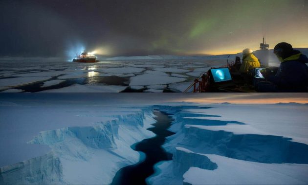
The ship’s floodlights cut a narrow tunnel through the polar night, bouncing off broken plates of sea ice like shards of glass. On deck, cameras and sonar gear hummed in the cold, recording a world no human eye would ever see directly. Scientists huddled around glowing screens inside, their breath fogging the air as bright bands of color slowly traced the unseen seafloor below Antarctica.
At first, the lines looked like noise. Then they sharpened into patterns: sharp drops, looping bends, branching scars that ran for hundreds of kilometers. Someone swore softly. Another scientist laughed in disbelief.
They weren’t looking at flat, frozen nothingness. They were staring at deep, sprawling canyons — a hidden underworld.
Antarctica’s secret landscape: a drowned Grand Canyon times hundreds
For decades, maps of the seafloor around Antarctica were basically polite guesses. Vast blank spaces. A few sketchy contours. Everyone imagined a featureless, gently sloping shelf buried under ice and silence. Then high-resolution sonar and satellite data started filling in the blanks.
What appeared wasn’t a calm seabed at all. It was shredded, carved, tangled. Picture the Grand Canyon, then multiply it, twist it, sink it under a kilometer of water, and stretch it along the frozen coast. That’s the new picture emerging from recent studies: hundreds of submarine canyons clawed deep into the bedrock all around Antarctica.
One international team mapped more than 450 submarine canyons along the Antarctic margin, some of them longer than major European rivers. On their screens, the biggest canyons dropped from the continental shelf like underwater cliff dives, plunging thousands of meters into the abyss. The scientists gave them names, traced their branches, measured their slopes.
In a few sectors, they realized they were sailing right above hidden valleys wider than cities, carved by ancient ice streams that once roared off the continent. These weren’t minor wrinkles. They were highways that guided ice, sediment, cold water, even nutrients, from the white edge of the ice sheet to the deep blue Southern Ocean. One researcher joked they’d basically discovered Antarctica’s “circulatory system.”
These canyons don’t just sit there, looking impressive on a map. They steer the way the ocean breathes. Dense, icy water formed near the coast sinks into them and spills downslope like ghost rivers, feeding the deep ocean circulation that affects climates thousands of kilometers away. Warm water, sneaking in from offshore, can ride the same channels in reverse, slipping under floating ice shelves and gnawing at their underbellies.
That means the exact shape of these canyons can decide which glaciers melt faster, which ice shelves survive another century, and how much sea level rises in your city. A small kink in one underwater valley can redirect a tongue of warm water straight under an ice front the size of a country. Suddenly, the fine detail of the Antarctic seafloor is a front-row story, not a footnote.
How you map a world you can’t see — and why we got it so wrong
Mapping these canyons is closer to performing a medical scan than drawing a coastline. Research vessels crawl along the ice edge, towing multibeam sonar systems that send sound pulses down to the seabed and listen for the echo. Each pass draws a narrow strip, a ribbon of depth data. Trip after trip, year after year, those strips are stitched into a 3D portrait of the hidden landscape.
➡️ Fresh foods that help cleanse the liver naturally and effectively in no time
➡️ If you feel emotionally “on standby,” psychology explains the learned readiness
➡️ Meteorologists warn early March signals suggest the Arctic is entering uncharted territory
Satellites add another layer, detecting tiny changes in sea-surface height that hint at mountains and trenches far below. It’s slow. It’s repetitive. It’s often done in brutal weather, with ice crunching against the hull and instruments freezing at the worst possible time. *Yet this is how a blank map becomes a story.*
For a long time, scientists had to interpolate between very few data points. One ship track might pass hundreds of kilometers away from where another had gone, leaving huge gaps. The result was a smoothed, almost polite version of reality, where all the roughness of the seafloor was averaged out. We’ve all been there, that moment when you zoom in on a digital map and hit the limit of detail — that’s what Antarctic science lived with for decades.
Now, with new expeditions, better sonar, and the massive BedMachine and Bedmap projects, those gaps are closing. One survey in the Amundsen Sea, for instance, revealed a canyon system that channels warm Circumpolar Deep Water straight under the Thwaites Glacier’s floating tongue. On the old maps, that area looked pretty unremarkable. On the new ones, it’s a loaded gun pointed at the ice sheet.
The big question is how we missed so much for so long. Part of the answer is simple: ships couldn’t get close enough. Thick sea ice barred access, and even when they did approach the ice front, the tech just wasn’t there to collect such dense data. Another part is human: we assumed the edges of Antarctica were, more or less, variations on a theme.
Let’s be honest: nobody really goes back to question every single “known” detail of a map unless there’s a strong reason. Climate change gave that reason. As glaciers started retreating faster than expected, researchers turned back to the fundamentals: What’s the shape beneath the ice? What’s the shape beneath the water? Every new canyon they mapped was another hint that the old mental picture of a simple, passive seafloor was never real.
Why these hidden canyons matter to your coastline, your weather, your lifetime
So what do you actually do with knowledge of hundreds of underwater canyons circling a frozen continent you’ll probably never see? Step one: plug them into the models that tell us how fast the ice will melt. Climate simulations used to smear out the seabed into coarse pixels, missing the narrow valleys that funnel warm water under ice shelves.
Now, teams are feeding the new canyon maps into their code. The models start to catch details they couldn’t reproduce before: why one glacier collapses while a neighboring one holds on, why melt rates spike in some areas and not others, why dense, super-cold water spills into the deep ocean in dramatic cascades in a few select spots. It’s like giving blurry glasses a long-overdue upgrade.
There’s also a quiet revolution happening in coastal risk planning. City planners and insurers in places like Miami, Rotterdam, Dhaka or Lagos don’t pore over seafloor maps themselves, but they do rely on projections of sea-level rise that are tuned by them. When Antarctic models change because we’ve found a canyon that speeds up melt under a major ice shelf, those numbers downstream shift.
Scientists are careful not to shout doomsday with every new dataset. Still, some of these discoveries point in a stark direction: in certain regions, the seafloor is practically built to invite warm water in, not keep it out. That matters if your home’s elevation is only one or two meters above high tide. It also matters for fisheries, as cold, nutrient-rich flows up and down these canyons shape where life thrives in the Southern Ocean food web.
The glaciologist Christine Dow summed it up bluntly in a recent conference talk: “We used to think of the Antarctic margin as a wall. What we’re seeing now is more like a maze of doors and corridors — and warm water has the keys.”
Inside this maze, several recurring themes keep coming up in the research:
- Gateways for warm waterMany of the newly mapped canyons act as direct pathways for slightly warmer deep water to reach the base of ice shelves. That speeds up thinning from below.
- Birthplaces of deep ocean waterSome canyons host gravity-driven “waterfalls” of cold, salty water that feed the global deep circulation, which in turn influences weather patterns far from Antarctica.
- Archives of past ice agesSediment piled in these valleys records how the ice sheet advanced and retreated over millions of years, helping scientists guess how it might respond to warming now.
- Hotspots of marine lifeWhere currents race through the canyons, nutrient-rich waters rise, feeding plankton blooms, krill swarms and the predators that depend on them.
- Unknowns that still loom largeHuge stretches of the Antarctic margin are still unmapped at fine scale, so the canyons we know about may be only a fraction of the real network.
A new way of seeing the edge of the world
Once you picture Antarctica not as a smooth white dome, but as a jagged continent fringed by drowned valleys, it’s hard to go back. The ice, the ocean, the climate above your head on some mild Tuesday in a temperate city — they’re all tied to what happens in those dark trenches no light reaches. The discovery of hundreds of submarine canyons doesn’t just update a map; it quietly rewrites who the main characters are in the climate story.
There’s a strange intimacy in that thought. A canyon no one will ever visit in person might decide whether a glacier holds for another century or lets go in a rush. A hidden slope beneath the Weddell Sea might tweak the temperature of deep waters that wash up, years later, along distant coasts.
These new images of the Antarctic seafloor are still young. They’ll be redrawn, refined, argued over. More autonomous submarines will dive under the ice shelves, more ships will push into risky waters, and the canyons we already know will gain friends and cousins on the map. What doesn’t change is the feeling that we’ve been underestimating this place — not just its scale, but its complexity.
As those maps sharpen, the distance between “down there” and “right here” gets a little thinner. Those silent valleys at the bottom of the world are not just geological curiosities. They’re part of the long, slow machinery that shapes the era we’re living in, whether we look at them or not.
| Key point | Detail | Value for the reader |
|---|---|---|
| Hidden canyon networks | Hundreds of submarine canyons ring Antarctica, carved deep into the continental margin and largely unmapped until recently. | Changes how we picture the planet’s last “blank” frontier and highlights how much of Earth’s story is still unseen. |
| Control on ice melt | Canyons channel warm deep water under ice shelves and guide the retreat of major glaciers like Thwaites and Pine Island. | Helps explain future sea-level changes that could affect homes, cities, and coastal infrastructure worldwide. |
| Link to global climate | Some valleys are birthplaces of dense deep waters that feed global ocean circulation and influence weather systems. | Connects distant polar processes to everyday climate impacts, from storms to shifting fisheries. |
FAQ:
- How many submarine canyons have been found around Antarctica?Recent compilations list more than 450 major submarine canyons, with many smaller branches and side valleys likely still unmapped in detail.
- How deep are these Antarctic canyons?Some drop from the continental shelf edge down several thousand meters into the deep ocean, with relief comparable to large terrestrial mountain ranges.
- Do these canyons increase ice melt?They can. Many act as conduits that guide relatively warm deep water beneath floating ice shelves, speeding up melting from below and contributing to glacier retreat.
- Can these canyons affect weather where I live?Indirectly, yes. By shaping where dense water forms and sinks, they influence the global overturning circulation, which helps regulate heat and carbon in the ocean and affects climate patterns worldwide.
- Is Antarctica’s seafloor now fully mapped?No. Large areas, especially under sea ice and near the ice shelves, remain poorly surveyed. The canyons already discovered are almost certainly only part of a much larger, still-hidden network.