Over the past decade, China has quietly turned remote reefs and shallow waters into solid ground, loading the sea with sand, concrete and steel. What began as obscure dredging operations has become a strategic transformation with consequences for regional security, the environment, and global trade.
The start of an ambitious land grab
The current phase of China’s island-building push really took off at the end of 2013. Chinese dredgers and engineering vessels moved into the Spratly and Paracel archipelagos — known in China as Nansha and Xisha — and began what analysts describe as one of the largest peacetime land reclamation efforts ever attempted.
In just 18 to 20 months, from December 2013 to mid‑2015, Beijing oversaw the transformation of at least seven coral reefs into sprawling artificial islands. According to the US‑China Economic and Security Review Commission, more than 12 square kilometres of new land appeared above the waves in that short window.
China created roughly 12 km² of new land in under two years — around 17 times more reclaimed area than its neighbours achieved in four decades.
That figure matters because these reefs sit in the middle of one of the world’s most contested maritime zones. Vietnam, the Philippines, Malaysia, Brunei and Taiwan all lay claim to parts of the Spratlys and Paracels. By turning submerged features into occupied, fortified islands, China has shifted the facts on the water in its favour.
How to build an island from a reef
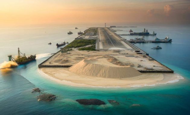
The engineering techniques used by Chinese crews are not especially novel; the scale is what makes them stand out. The basic process is brutal but effective.
From coral shelf to runway
First, dredgers cut into the coral seabed, chewing away at the reef and nearby shallow zones. High‑powered pumps then suck up sand and sediment and blast the slurry onto the chosen reef like a giant hose. Over weeks and months, the material piles up above the high‑tide line, forming an emerging platform.
To keep this new land from washing away, workers install retaining walls, piles and circular revetments. Once a stable perimeter is in place, the infill is compacted by heavy rollers and excavators to reduce settling and increase load‑bearing strength. Only then does the surface work begin: grading, paving, and laying out roads, storage areas and runways.
What looks from space like a natural atoll is, in reality, dredged sand pinned in place by concrete, steel and coral rubble.
➡️ Growing up in the 60s/70s: the life skill many learned naturally that we now have to practice
➡️ In 2026, these four zodiac signs are set to become millionaires
➡️ Over 65? This mental habit helps adapt to physical changes more smoothly
➡️ China officially commissions its third aircraft carrier, the Fujian
Satellite imagery, including historical layers on Google Earth, shows the progression almost like a flipbook: blue reef, milky plumes of sediment, a pale sandbank, then a geometric lattice of roads and buildings.
From bare sandbars to fortified outposts
Once the basic landmass exists, the transformation speeds up. Since 2015, China has covered several of these new islands with strategic infrastructure.
Runways, radars and harbours
Analysts following open‑source satellite images have identified a pattern of construction:
- Long airstrips capable of handling transport aircraft and fighter jets
- Large hangars and hardened shelters for planes and drones
- Piers and deepened channels for military and coast guard vessels
- Radar domes, communication towers and electronic surveillance arrays
- Fuel depots, warehouses and power generation facilities
- Living quarters for personnel, plus administrative buildings
Many of these islands now host multi‑role bases that can support both civilian and military operations. Officially, Beijing describes some facilities as helping weather observation, search‑and‑rescue and navigation safety. Security experts point out that the same infrastructure also extends the reach of Chinese naval, air and coast guard forces deep into contested waters.
The new islands function as fixed aircraft carriers and unsinkable outposts, projecting Chinese presence hundreds of miles from its mainland coast.
Why these specks of land matter
The South China Sea is not just a remote patch of ocean on a map. Roughly a third of global shipping traffic passes through its lanes, carrying energy supplies and manufactured goods between Asia, the Middle East and Europe. Below the seabed lie oil and gas reserves. Above, rich fishing grounds sustain coastal communities.
Control of islands and reefs has legal and practical consequences. Under the UN Convention on the Law of the Sea (UNCLOS), naturally formed islands that can sustain human life can generate territorial seas and exclusive economic zones. Artificial islands, by contrast, do not create such zones. China argues that its constructions sit on features it already considers its own; many neighbouring states and legal experts reject that view.
Growing tension with neighbours
The result is a slow, persistent pressure on Southeast Asian countries. The Philippines has clashed with Chinese vessels near disputed reefs. Vietnamese fishing boats report harassment by coast guard ships operating from nearby artificial islands. Malaysia and Indonesia watch nervously as law‑enforcement and survey vessels push closer to their claimed zones.
US and allied navies carry out so‑called “freedom of navigation” operations, sailing warships near or through waters around these new islands to challenge what they see as excessive maritime claims. That, in turn, feeds Beijing’s narrative that foreign powers are intruding into what it treats as its backyard.
The environmental cost under the waves
Beyond geopolitics, the reef‑to‑runway transformation hits fragile ecosystems. Coral reefs support a huge diversity of marine life, acting as nurseries for many fish species. Blasting and dredging physically destroy the coral structures; sediment clouds can smother reefs kilometres away.
| Stage of construction | Main environmental impact |
|---|---|
| Dredging and blasting | Direct destruction of coral and seabed habitats |
| Sand deposition | High turbidity, sediment plumes, suffocating nearby reefs |
| Compaction and paving | Permanent loss of reef surface, changes in water flow |
| Operational use | Pollution, fuel spills, ship traffic, noise impacts on wildlife |
Marine biologists warn that once a reef is buried under metres of dredged material and concrete, recovery chances are slim. Even if some corals survive on the fringes, the complex three‑dimensional structure that sheltered fish, molluscs and crustaceans is largely gone.
What “land reclamation” really means
The phrase “land reclamation” sounds almost gentle, as if lost land were being restored. In reality, it often means converting a natural marine environment into an engineered one for human use.
Many coastal cities have done something similar on a smaller scale. Singapore has extended its shoreline with imported sand. Dubai built palm‑shaped islands for housing and tourism. The difference in the South China Sea is that this reclamation intersects with military strategy and unresolved territorial disputes.
Land reclaimed from the sea is not just real estate; in contested waters, it becomes a physical statement of power and intent.
Possible futures: escalation, stalemate, or rules
Several scenarios lie ahead. One is continued militarisation, where new radar systems, missile batteries and anti‑submarine networks gradually turn the area into a dense security zone. That raises the risk of miscalculation when opposing ships or aircraft operate in close proximity.
Another scenario is a tense but stable stalemate, in which the current artificial islands stay in place and are gradually “normalised” as part of daily operations, while diplomatic talks drag on without clear resolution. Regional states might respond by boosting their own defences, buying more coastal missiles, submarines or patrol aircraft.
A third path would involve stronger regional agreements: notification rules for military exercises, shared fishing arrangements, or binding mechanisms to manage incidents at sea. None of these remove the islands, but they can reduce the chances that a collision or an arrest spirals into a wider crisis.
Key terms and concepts worth unpacking
Three technical terms recur in discussions about these islands:
- Artificial island: A human‑made structure built on or above the sea, usually from rock, sand or concrete, that did not previously exist as natural land.
- Dredging: The process of excavating material from the seabed, often using suction or mechanical buckets, to deepen channels or gather fill for construction.
- EEZ (exclusive economic zone): A sea zone extending up to 200 nautical miles from a state’s coast where it has special rights to exploit marine resources, subject to international law.
Understanding these concepts helps clarify what is at stake: not just tiny strips of sand, but the rules governing who can fish, drill, patrol or simply sail through some of the busiest waters on Earth.
Artificial islands will likely remain part of the seascape for decades, even if political winds shift. Their sand and concrete foundations are fixed, but how states choose to use them — as platforms for cooperation, or as stepping‑stones in a confrontation — is still being written.